- Details
- Monday, 20 October 2014 - 7:52:36 PM

Location, Accessibility Area
The City of Batangas is a coastal city lying in a cove like shape at the southeastern portion of Batangas Province and geographically situated at coordinates 13 degrees, 45 minutes and 25.96 seconds north latitude and 121 degrees, 3 minutes and 29.2 seconds east longitude (13°45'18.91", 120°3'32.76"). It is bounded on the northwest by the municipality of San Pascual; on the north by the municipality of San Jose; on the east by the municipalities of Ibaan, Taysan and Lobo; and on the south by the Batangas Bay.
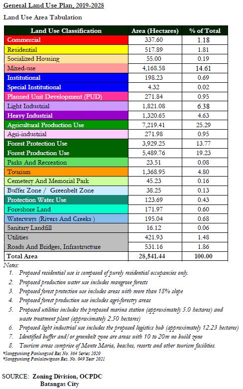
Batangas City, the capital of Batangas Province has a total land area of more or less 28,541.44 hectares. It is about 108.00 kilometers away from Manila and has an average travel time of approximately one hour forty-five minutes through the Southern Tagalog Arterial Road (STAR) tollway and the South Luzon Expressway (SLEX).
Topography, Slope and Elevation
The City’s northern area is predominantly flat with slopes ranging from 0% to 8%. The westernmost boundary of the city including some portions of barangays Sorosoro Ibaba and Tingga Itaas, have slopers of over 50%.
Unlike the northern area, the southern area’s terrain can be characterized as very steep terrain. A small portion on the western side – barangays Malitam, Libjo, Tabangao Ambulong and Pinamucan Ibaba where the industrial plants are mostly located, have relatively flat lands. Towards the southeast, elevations increase, and slopes get steeper especially in barangay Simlong, Malibayo, San Miguel, Sto. Niño, Cumba, Talumpok Silangan, Talumpok Kanluran, Sto. Domingo, Talahib Payapa and a portion of San Jose Sico. The highest elevation is Mt. Banoy in barangay Talumpok Silangan, which is approximately 968 meters above sea level (masl).
Accounting for 35.49% of the total land area, the predominant slope category of the City is 8% - 15%, which can be described as “undulating” to “rolling”. Relatively flat areas comprise 23.69% of the total land area, while steep areas account to 34.20%. Overall, the City is characterized with a well-spread terrain of various categories, giving rise to both opportunities and disadvantages.
Slope and Land Area Percentage Distribution
| SLOPE CATEGORY | LAND AREA (has) | % OF TOTAL |
| Main River | 122.29 | 0.43% |
| 0% – 3% | 2,253.39 | 7.90% |
| 3% - 8% | 4,505.76 | 15.79% |
| 8% - 15% | 10,127.99 | 35.49% |
| 15% - 25% | 1,772.42 | 6.21% |
| 25% - 50% | 3,609.32 | 12.65% |
| Above 50% | 6,150.27 | 21.55% |
| TOTAL | 28,541.44 | 100.00% |
Climate Condition
Batangas City is generally coolest during the months of December to January with temperature ranging from 22ºC to 26ºC. The mean temperature rises and attains a maximum of 36 degrees Celsius (36ºC) in April and May. The month of September marks the steady fall of temperature.
The driest months in Batangas City are from January to April, with the average monthly rainfall of less than 50 mm per month.
The northeast monsoon or locally known as “amihan” prevails starting the months of November up to April. Although originally moist, it becomes comparatively drier after crossing the Sierra Madre Range to the north and east of Batangas, thus attributing for predominantly dry weather during this period. The situation is reversed from the latter part of May or June to the later part of October.
The southwest monsoon or locally known as “habagat” prevails bringing with it considerable rain. A pronounced maximum rain period occurs in the city during the months of June, July, August and September when southwest monsoon flow is steadiest, and the average monthly rainfall is 275 mm per month. By the latter part of October, the northeast monsoon starts to set again.
However, the months from October to December are not characterized by dry weather as compared to the months from January to April. This is partly due to the fact that typhoons and depressions most frequently affect the city during the months from July to December and in some instances because of the effect of climate change, the tropical storms sometimes occur during months of April to June.
Soil Types and Location
There are seven (7) types of soil that composed the land area of Batangas City.
Their types, location and agricultural potentials are as follows:
| Type of Soil | : Taal Sandy Loam |
| Location | : Sta. Rita Karsada, Sta. Rita Aplaya, Sta. Clara and Cuta |
| Agricultural Potentials | : corn, citrus, sugar cane, fruit trees |
| Type of Soil | : Hydrosoil |
| Location | : Calicanto and Wawa |
| Agricultural Potentials | : salt beds and fishponds |
| Type of Soil | : Calumpang Clay Loam |
| Location | : Libjo, Poblacion and Pallocan Kanluran |
| Agricultural Potentials | : Sugar Cane |
| Type of Soil | : Ibaan Clay Loam |
| Location | : Pinamucan, Mahabang Dahilig, Malalim, Sirang Lupa, Conde, Talumpok, Kanluran/Silangan, Sto. Niño, Tulo, Paharang Kanluran/Silangan |
| Agricultural Potentials | : sugar cane, upland crops, rice and intercrops |
| Type of Soil | : Ibaan Loam |
| Location | : Balete, Concepcion, Bucal, Mahabang Parang, Sorosoro Karsada/Ibaba/Ilaya, Tingga Labac/Itaas, Banaba, Balagtas, Alangilan, Bolbok, Kumintang Ilaya/Ibaba, San Pedro, Dumantay, Dalig, Gulod Labac/Itaas, Sampaga, San Isidro, Tabangao Ambulong and Tabangao Aplaya |
| Agricultural Potentials | : sugar cane, upland rice, corn, vegetables, coffee, bananas, fruit bearing trees |
| Type of Soil | : Ibaan Loam (Gravely Phase) |
| Location | : Talumpok Kanluran/Silangan, Conde Labac/Itaas, San Miguel, Sto. Niño, Tabangao Dao, Haligue, Talahib Payapa, Talahib Pandayan, Mabacong, Ilijan and Dela Paz Proper/Aplaya/Pulot Itaas |
| Agricultural Potentials | : coconut, atis, cacao and coffee |
| Type of Soil | : Sibul Clay |
| Location | : Isla Verde (6 barangays) |
| Agricultural Potentials | : upland rice, peanuts and vegetables |
Mineral Resources
Several mineral resources can be found in the city and some of the deposits have not yet been extracted. Traces of metallic mineral like gold and non-metallic mineral like gypsum are being detected in the mountainous area of barangays Sto. Domingo and Cumba.
Salt beds originally existed abundantly in barangays Sta. Clara and Malitam but rapid urbanization and the expansion/development of the Batangas Port likewise resulted to the end of this industry.
Land Use
The land use of the city has considerably changed from 1946 to 1981 from a major agricultural use to a rapidly developing major urban center and from 1981 up to the present to a major urban commercial and industrial center.
Water Resources
Batangas City is traversed by numerous creeks and streams that converge at the Calumpang River which in turn flows into the Batangas Bay.
Calumpang River is a perennial body of water with a catchment area of approximately 472.00 square kilometers. The river serves as the southeastern boundary of the Poblacion and it flows into the Batangas Bay at a point approximately two kilometers south of Batangas Port. It has an appropriate length of eight (8) kilometers and average width of 54-165 meters and average depth of 0.27-5.37 meters.
There are several springs in Batangas City that has sufficient volume of discharge to suffice the needs of nearby residents for their water supply requirements. These can be found in barangays Talumpok Kanluran & Silangan, Cumba, Sto. Domingo, Talahib Pandayan, Talahib Payapa, Ilijan, Malibayo, Haligue Kanluran, Haligue Silangan, Maruclap and Conde Itaas.

City Profile
Emergency Hotlines
![]() Mayor's Action Center : 723-1511
Mayor's Action Center : 723-1511
![]() BFP Batangas City : 425-7163
BFP Batangas City : 425-7163
![]() PNP Batangas City : 723-2030
PNP Batangas City : 723-2030
![]() Nazareth Hospital : 723-4144
Nazareth Hospital : 723-4144
![]() Batangas Medical Center : 723-0911
Batangas Medical Center : 723-0911
![]() CDRRMO : 702-3902
CDRRMO : 702-3902
![]() Philippine Red Cross: 723-3027
Philippine Red Cross: 723-3027
![]() City Social Welfare Dev’t : 723-2357
City Social Welfare Dev’t : 723-2357
![]() City Health Office : 723-8890
City Health Office : 723-8890
![]() LTO Batangas City : 740-9738
LTO Batangas City : 740-9738
![]() LTO Batangas City : 740-9738
LTO Batangas City : 740-9738
Contact Info
Mayor Beverley Rose A. Dimacuha
Batangas City Hall Complex,
P. Burgos Street, Barangay 17,
Batangas City, Batangas
Philippines 4200
Location Map
Links


![]()
